


Alert
The lake is being maintained at a low level for dam assessment and repair. Any water level rise is followed by a fast drawdown.
All ramps are blocked off except for the gravel one into the north river channel at Hwy 51 landing parking lot. How far you can go there is limited by river flow and/or lake level. Creek and riverbank fishing are other options.
For COE regulations, see: US Army Corps of Engineers
Fishing Report
Arkabutla - 4/23/2024 2:11:17 PM| Species | Detail | |
| Fish | Some folks are bank or kayak fishing in creek and river pools. Catfish have been biting in the creeks and river during rainfall runoff. White bass should be spawning in the creeks and river over sand bars. Crappie should be spawning, too, but they will spawn deeper than normal due to rapid water level fluctuations. Use baits and lures appropriate for your target fish (ex. soft plastics for bass, jigs for crappie, natural baits for catfish). | |
All fishing regulations remain in effect. It is a good time to take pictures or waypoints of bottom cover or habitat for when the lake refills. Be very careful around steep banks or soft bottomed areas. Some fish have survived in the main lake, sloughs, and creek and river channels.
Fish may move up with a water rise and then get concentrated in remaining pools when it goes back down. Shallower water warms up and cools off faster than deeper water. Check water level trends; except for catfish, fishing is usually better on a slow fall than a fast rise. Just be aware the ups and downs will be very rapid.
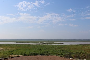
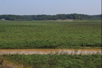
The extended drawdown is allowing vegetation to colonize exposed areas, providing habitat, cover, and food for fish, aquatic invertebrates, waterfowl, and other wildlife when re-flooded. Flooded vegetation also settles sediment out of the water. Views from Hernando Point ramp (below, left) and across Hurricane Creek bottom Sept 7 (below, right).
Special Fishing RegulationsSpecies |
||
| Species | Type | Length To Release |
| Crappie (combined black and white) | Minimum Length Limit | 12 inches and under |
Creel Limits (per person, per day) |
||
| Type | Amount | Additional Information |
| Crappie (combined black and white) | 15 | There is a 40 crappie per boat limit for boats with 3 or more anglers. |
Anglers may use no more than 4 poles per person and no more than 2 hooks or lures per pole.
Spillway
The spillway area is closed to fishing because of the dam repair.
The spillway had two gates open 3.0 ft each, one gate open 19.0 ft (1695 cfs) Tuesday. Spillway gate openings, flow rates, and spillway water elevations can be obtained at Vicksburg District Corps of Engineers OR Yazoo River Basin Reservoirs click on 24-hour change for picture explanation of gate flow, spillway flow, etc.).
All fish captured and kept with dip or landing nets, cast nets, boat mounted scoops, wire baskets, minnow seines, and minnow traps in the spillway areas bordered by rip rap must be immediately placed on ice or in a dry container. Game fish caught with these gears must be released. This regulation was enacted to reduce the potential of transferring harmful Asian carps to the reservoir or other waters.
The 12-inch crappie length limit does not apply to the reservoir spillway, but the spillway has a 15-crappie creel limit.
Water Level
Water level 205.44, falling 0.9 ft/day, 4.6 ft below the rule curve Tuesday. The water is being drawn back down after recent rains. Expect very rapid rises and drawdowns as rain events happen and the Corps tries to maintain a low water level. Ignore the rule curve as the COE maintains low water to assess and repair the dam. Emergency spillway level is 238.3. For water level information, call (662)562-6261 or check at Vicksburg District Daily Bulletin for a table OR Coldwater River @ Arkabutla Dam, MS for a graph OR Yazoo River Basin Reservoirs for both (click on 24-hour change for picture explanation of gate flow, spillway flow, etc.). Be sure to check the date on the table; it is usually updated midday.
Additional Information
Mississippi Department of Wildlife, Fisheries, and Parks Fisheries Biologists use various sampling methods to assess the fish populations in the State’s waters. Sampling results for selected water bodies are summarized in Reel Facts Sheets.

