


UPDATE: Hunting season closures due to flooding
1/16/2020 3:24:24 PM
From MDWFP
Heavy rains and rising Mississippi River levels have hunters yet again looking down the barrel of hunting season closures. As a result of these high-water levels, all hunting except for waterfowl, will close based on these parameters (projected date of closure levels listed for each zone):
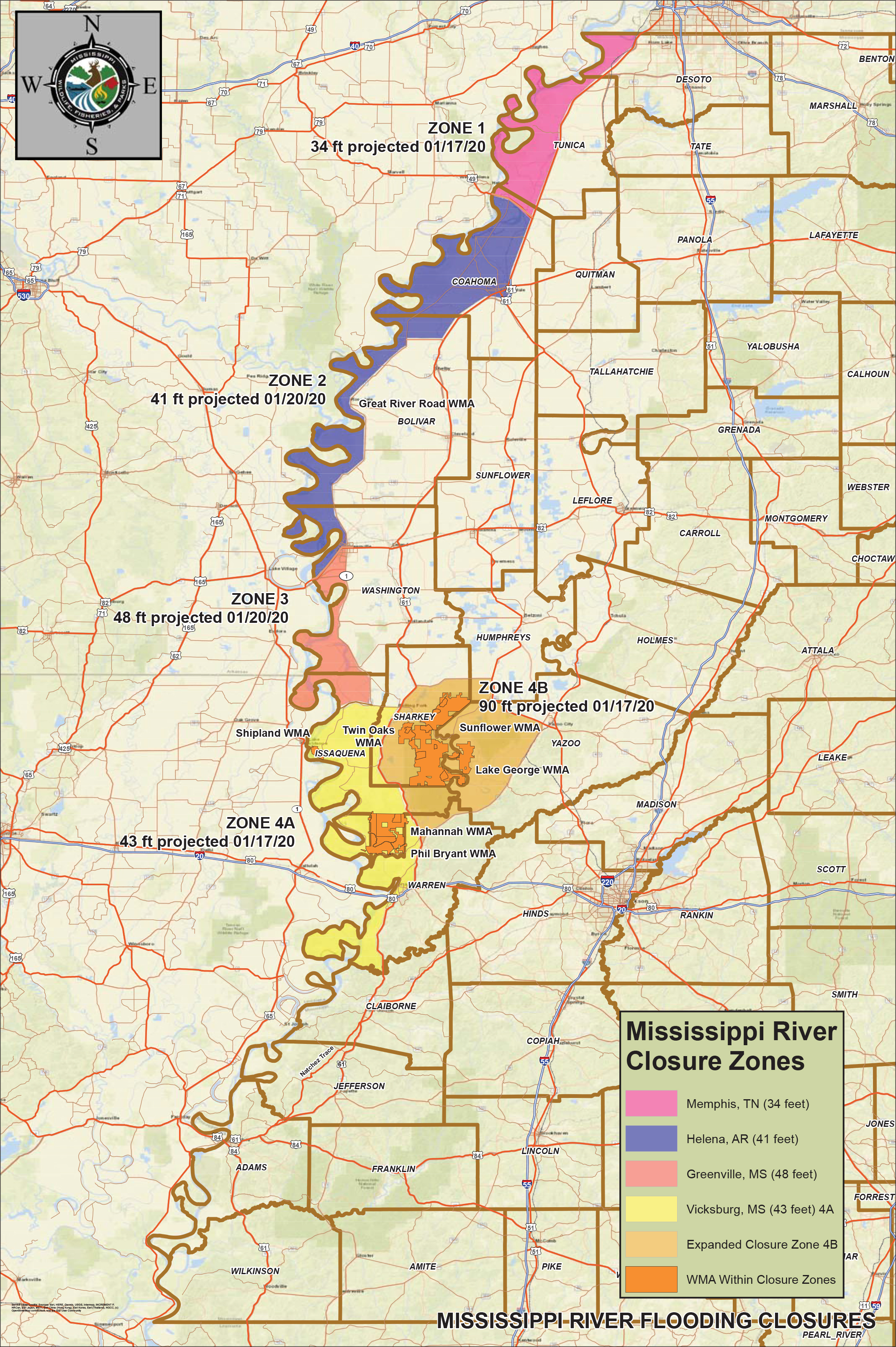
click to enlarge
Zone 1: (Projected to reach 34 ft on Tuesday, Jan. 21)
When the Memphis, Tennessee gauge reaches thirty-four (34) feet and shall remain so until the Mississippi River level falls to or below 32 feet. (Lands in DeSoto, Tunica and Coahoma counties which lie south of Tennessee state line, west of Highway 61 and north of Highway 49)
Zone 2: (Projected to reach 41 ft on Monday, Jan. 20)
When the Helena, Arkansas gauge reaches forty-one (41) feet and shall remain so until the Mississippi River level falls to or below 39 feet. (Lands in Coahoma, Bolivar and Washington counties which lie south of Highway 49, west of Highway 61 to the intersection of Highway 61 and Highway 444, west of Highway 1 and north of Highway 82)
Zone 3: (Projected to reach 48 ft on Monday, Jan. 20)
When the Greenville, MS gauge reaches forty-eight (48) feet and shall remain so until the Mississippi River level falls to or below 46 feet. (Lands in Washington and Issaquena counties which lie south of Highway 82, west of Highway 1, and north of Hwy 14)
Zone 4: (Projected to reach 43 ft on Friday, Jan. 17)
When the Vicksburg, MS gauge reaches forty-three (43) feet and shall remain so until the Mississippi River level falls to or below 41 feet. (Lands in Issaquena, Sharkey and Warren counties which lie south of Highway 14, west of Highway 61, and north of the Big Black River)
The following Wildlife Management Areas (WMA): Shipland, Mahannah, Phil Bryant
Zone 4B: (Projected to reach 90 ft on Friday, Jan. 17)
When the Steele Bayou gauge reaches 90 feet and shall remain so until the Steele Bayou level falls to or below 88 feet. (Lands in Sharkey, Humphreys, Yazoo, Issaquena, Warren counties which lie south of Highway 14, west of Highway 149, south of Highway 16 / 149, west of Highway 3, and east of Highway 61
- The following Wildlife Management Areas (WMA): Lake George, Twin Oaks, and Sunflower.
- The U.S. Fish and Wildlife Service has closed Panther Swamp National Wildlife Refuge, including the Carter Unit, consistent with state regulations. In addition, the Brown Tract on the northeast side of Delta National Forest is closed to all hunting until floodwaters recede.
MDWFP will increase its law enforcement presence in the affected areas to patrol the levees, ensure public safety for residents affected by rising waters, and enforce wildlife laws that protect animals displaced by floodwaters.
For more information about this closure and to view a map displaying closure zones please visit our website at www.mdwfp.com or call us at 601-432-2400. Follow us on Facebook at www.facebook.com/mdwfp or on Twitter at www.twitter.com/MDWFPonline.

