


Alert
The boat ramp is open at this time.
Fishing Report
Lake Claude Bennett - 4/22/2024 3:50:21 PM| Species | Detail | |
| Largemouth Bass | Bass fishing has been fair. Try fishing along the edges on various artificial baits such as lizards in junebug, green pumpkin, or black/blue. | |
| Crappie | Crappie fishing has been fair. Try crappie fishing along the dropoffs and throughout the deep water with minnows or jigs. | |
| Bream | Bream fishing is fair. Try targeting bream at depths of 2 - 10 ft around brush piles or creek channels with crickets or red worms. | |
| Catfish | No new report. Catfish should be targeted at depths of 8 - 15 ft along creek ledges and deep structure. Chicken liver or worms should be good choices for bait. | |
Water Temperature: 65°F Water visibility: 33 inches
Report provided by Mr. Jim Bufkin, Lake Claude Bennet Manager
Special Fishing RegulationsSpecies |
||
| Species | Type | Length To Release |
| Catfish | No length limit | |
Creel Limits (per person, per day) |
||
| Type | Amount | Additional Information |
| Catfish | 10 | Creel limit for all State Fishing and State Park Lakes |
- Only rod and reel or pole fishing is allowed on State Fishing Lakes except that carp, gar, buffalo, and bowfin may be taken by use of bow and arrow at night only after purchasing a valid permit for fishing and/or boating. No other gear is allowed at these lakes.
- Fishing is not allowed from courtesy piers adjacent to boat ramps. Night fishing is allowed from the bank or boats which are in compliance with state and coast guard regulations.
Additional Information:
For information about Lake Claude Bennett, please call (601) 727-3561.
Mississippi Department of Wildlife, Fisheries, and Parks Fisheries Biologists use various sampling methods to assess the fish populations in the State’s waters. Sampling results for selected water bodies are summarized in Reel Facts Sheets.
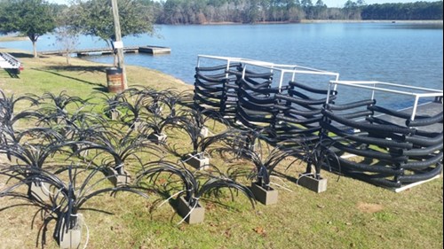
Four different groups of artificial structures along with natural habitat were added on 1/24/17. There were 20 artificial grass structures and three 5x5x5 artificial box structures placed at each site. The coordinates for these are listed below.
|
Artificial Structures N 32.10126 W 89.03272 N 32.10471 W 89.03394 N 32.10353 W 89.03681 N 32.10111 W 89.03254 |
Hardwood Structures N 32.10117 W 89.03296 N 32.10422 W 89.03283 N 32.10451 W 89.03358 N 92.10343 W 89.03650 |
GPS coordinates that were added on 12/17/14 are listed below.
|
N 32.10377 N 32.10370 N 32.16356 N 32.10347 N 32.10340 N 32.10316 N 32.10341 N 32.10337 N 32.10328 N 32.10318 N 32.10317 N 32.10320 N 32.10295 N 32.10273 N 32.10256 N 32.10246 N 32.10242 N 32.10241 N 32.10236 N 32.10205 |
W 89.03727 W 89.03736 W 89.03725 W 89.03755 W 89.03781 W 89.03800 W 89.03819 W 89.03838 W 89.03857 W 89.03857 W 89.03841 W 89.03826 W 89.03812 W 89.03779 W 89.03801 W 89.03859 W 89.03844 W 89.03905 W 89.03867 W 89.03836 |
N 32.10214 N 32.10186 N 32.10147 N 32.10128 N 32.10149 N 32.10098 N 32.10109 N 32.10090 N 32.10067 N 32.10104 N 32.10206 N 32.10162 N 32.10035 N 32.10015 N 32.09993 N 32.09996 N 32.10023 N 32.10011 N 32.10027 N 32.10402 |
W 89.03806 W 89.03797 W 89.03799 W 89.03804 W 89.03829 W 89.03822 W 89.03844 W 89.03857 W 89.03843 W 89.03777 W 89.03771 W 89.03778 W 89.03802 W 89.03808 W 89.03819 W 89.03804 W 89.03798 W 89.03793 W 89.03783 W 89.03310 |

